Back Sawmill Run (suba sa Tinipong Bansa, Pennsylvania, Allegheny County, lat 40,44, long -80,03) CEB
| Saw Mill Run Tributary to Ohio River | |
|---|---|
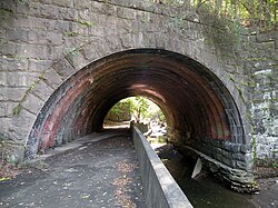
 The Seldom Seen Arch, built in 1903, over Saw Mill Run along Saw Mill Run Boulevard not far from Woodruff Street in the Beechview neighborhood of Pittsburgh, Pennsylvania | |
| Location | |
| Country | United States |
| State | Pennsylvania |
| County | Allegheny County |
| City | Pittsburgh |
| Borough/Township | Castle Shannon Mt. Lebanon |
| Physical characteristics | |
| Source | McLaughlin Run divide |
| • location | Mt. Lebanon, Pennsylvania |
| • coordinates | 40°21′14″N 080°02′24″W / 40.35389°N 80.04000°W[1] |
| • elevation | 1,250 ft (380 m)[2] |
| Mouth | Ohio River |
• location | Saw Mill Run Boulevard and Carson Street, Pittsburgh, Pennsylvania |
• coordinates | 40°26′41″N 080°01′39″W / 40.44472°N 80.02750°W[1] |
• elevation | 710 ft (220 m)[3] |
| Length | 9.12 mi (14.68 km)[4] |
| Basin size | 19.42 square miles (50.3 km2)[5] |
| Discharge | |
| • location | Ohio River |
| • average | 19.57 cu ft/s (0.554 m3/s) at mouth with Ohio River[5] |
| Basin features | |
| Progression | northeast then northwest[4] |
| River system | Ohio River |
| Tributaries | |
| • left | unnamed tributaries |
| • right | unnamed tributaries |
| Bridges | Santa Fe Drive, Caswell Drive, Milford Drive (x2), Connor Road, Willow Avenue, Canal Street, Castle Shannon Boulevard, Killarney Drive, PA 88, Kingwood Street, PA 51 (x2), Whited Street, PA 51, Fawn Street, Fine Way. PA 51, Edgebrook Avenue, PA 51 (x2), Crane Avenue, I-376, Miniotte Square, Neptune Street, S Main Street, PA 51 |
Saw Mill Run is a tributary of the Ohio River in Pennsylvania. It is an urban stream, and lies entirely within Allegheny County, Pennsylvania. The stream enters the Ohio just downstream from the Forks of the Ohio in Pittsburgh, at a place that was founded as the town of Temperanceville in the 1830s. It provides an entry through the elevated plateau south of Pittsburgh known as the South Hills, and land transportation has paralleled the stream since the nineteenth century.
The stream is named for an actual saw mill that operated near the mouth of the stream where it empties into the Ohio River. The first reference to the mill is in relation to the construction of Fort Pitt (1759–1761). The mill provided much of the lumber used in the construction of the new Fort, after the British claimed the area from the French and destroyed Fort Duquesne.[6]
- ^ a b "GNIS Detail - Sawmill Run". geonames.usgs.gov. US Geological Survey. Retrieved 12 May 2021.
- ^ "Get Maps". USGS Topoview. US Geological Survey. Retrieved 12 May 2021.
- ^ "Get Maps". USGS Topoview. US Geological Survey. Retrieved 12 May 2021.
- ^ a b "ArcGIS Web Application". epa.maps.arcgis.com. US EPA. Retrieved 12 May 2021.
- ^ a b "Sawmill Run Watershed Report". US EPA Geoviewer. US EPA. Retrieved 12 May 2021.
- ^ Lorant, Stefan (1999). Pittsburgh: The story of an American city (5th ed.). Esselmont Books. ISBN 0967410304. OCLC 42704989.

